
Hot Pick
Innocent campaign is jam-packed with goodness
Neverland helps bring to life the amount of fruit, veg and vitamins in Innocent smoothies and juices
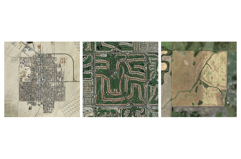
The Jefferson Grid

As a child growing up, and often as an adult muddling through day-to-day life, we are constantly told to think outside the box; devise new ideas; throw away the rule book. But what if you harnessed the box and used it for your own ends?
This is exactly what an anonymous Israeli photography student is doing through their Instagram account, @the.jefferson.grid, capturing the beauty of a regimented breakdown of the American landscape.
The account takes its name from Thomas Jefferson, the third President of the United States. He devised a grid system more than two centuries ago as part of the Public Land Survey System, that divvies up America into square mile sections. The checkerboard plan was created to enable the Americans to neatly divide up their newly acquired lands after the American Revolutionary War.
Jefferson never saw his system in action, from above. @the.jefferson.grid is a visual, bird’s eye documentation of the Grid as it’s being used all over the US.
The account uses images from Google Earth to curate a view of America totally abstracted from what the places actually look like on the ground. The landscape takes on a beautifully captivating quality when seen from the air, affording a viewpoint that showcases the diversity of the American landscape. From the Nevada desert, to Wisconsin fields, and agricultural circles in Utah, the logic of the system affords itself to capturing all manner of spaces and landscapes across America.
The format of the Jefferson Grid lends itself perfectly to Instagram’s platform, where the images are also displayed within a grid. But the sentiment of the account remains: “Even when you go off the grid, you might still be on it”.
Visit the Jefferson Grid website to view the entire gallery.
Looks like you need to create a Creativebrief account to perform this action.
Create account Sign inLooks like you need to create a Creativebrief account to perform this action.
Create account Sign in